Running the Hadrian’s Wall route covers three counties and a beautiful part of the world I’d always wanted to experience.
I decided to run Hadrian’s Wall mid-pandemic in August last Summer. I did so to raise money for St Leonard’s Hospice in York who cared for my late wife, Natalie, over the course of a year with her cancer (please check them out and consider donating to help them continue their amazing work).
Truth be told, a tiny part of me also did it for myself. After the long lockdown I wanted to tick a few of my bucket list European trail running trails in addition to raising money for such a wonderful charity.
Finishing Hadrian’s Wall in 3 days took some planning so I wanted to share everything I can to help others considering doing the same.
Much of the advice is applicable to anyone walking Hadrian’s Wall route – something most people choose to do across 5-7 days.
→ Related reading: Ultimate Hadrian’s Wall Packing Guide
About the Hadrian’s Wall Run Route
Hadrian’s Wall Path is a National Trails hiking and walking route spanning 84 miles coast-to-coast across the north of England. Slightly longer than the 80 Roman miles long Wall.
Now a UNESCO World Heritage Site, Hadrian’s Wall was built in AD 122 at the height of the Roman Empire by Emperor Hadrian to keep the threat of a Scottish invasion at bay.
The Hadrian’s Wall route has its own distinct markers. Remembering these will help you when retracing the wall. At every Roman mile was a small fort which acted as a fortified gateway through the Wall, known as a ‘milecastle’. Between every two milecastles were two small watch towers (‘turrets’) approximately 30ft in height.
The Roman army was stationed along the wall in 15 major garrison forts. The last defining feature you’ll encounter is the ‘Vallum’ or ditch, 6m wide and 3m deep, that runs alongside much of the wall beyond Newcastle.
The 84 mile path from Bowness-on-Solway to Wallsend crosses through a mix of majestic landscapes and terrains, particularly in the popular middle section through Northumberland National Park.
You’ll hug the coastline, encounter farm tracks and remote paths, see Roman ruins and fully intact sections of the Wall, cross urban areas built on top of the wall, and be grateful for the odd lifesaving ice cream van. The only thing I failed to spot in all the 3 days was another runner!
I’m a keen runner but this would stretch me – running 60km, 40km, 40km in consecutive days. Most people choose to walk Hadrian’s Wall in 5-7 days. There’s plenty to stop and see along the way if you’re in less of a hurry. As an avid plogger, I also took the opportunity to collect litter on the Hadrian’s Wall route.
How Difficult is it to Run Hadrian’s Wall?
In one go, very difficult. That’s on account of the 84 mile distance, not the elevation as the highest point on the path is only 345 m (1130 ft) high.
However, walk or run Hadrian’s Wall across multiple days and it’s very accessible. Completing it over 3 days benefited from 6 months’ training, covering many awe runs, heritage site treks (e.g. Kirkham Priory circular route) and daily jogs to build up my fitness and endurance.
💌 Inspiring Run Stories.. in Your Inbox
Best Direction to do Hadrian’s Wall
Travel West to East: Bowness-on-Solway to Wallsend.
This ensures you’re not running or walking into the wind, sun or rain.
Hadrian’s Wall GPS Map – a Lifesaver!
I downloaded and followed this Hadrian’s Wall GPS (GPX) file for my Garmin GPS watch.
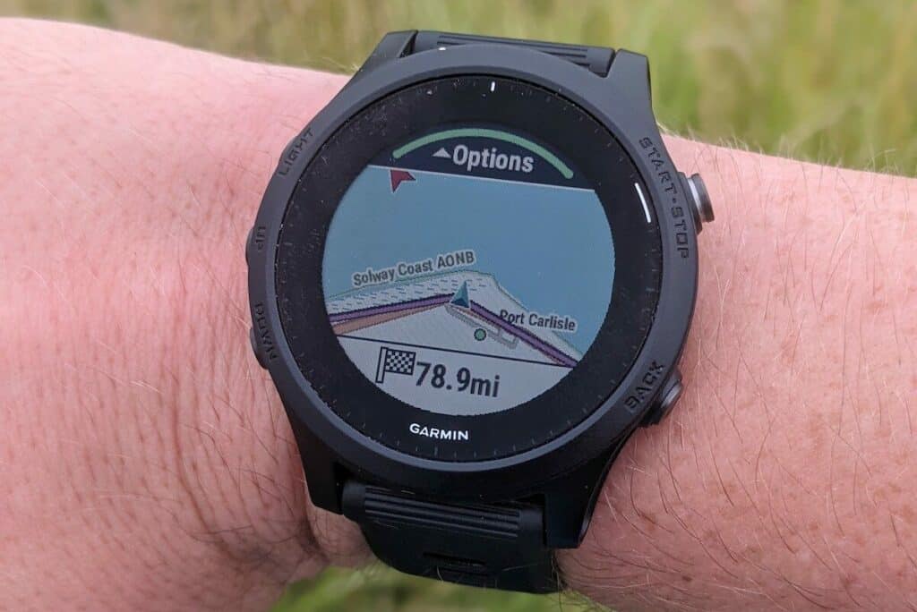
The above Hadrian’s Wall run route is East to West, so you’ll want to reverse it in the watch, which is easily done.
My GPS watch saved me at times as it’s far easier to look down at your wrist than it is constantly checking a map. It also kept me on track when the famous acorns were hard to find or paths were closed for maintenance. Everybody loves a plot twist, unless you’re doing marathon distances.
My Hadrian’s Wall 3-Day Itinerary

- Night 0: Crown Hotel, Wetheral
- Day 1 morning: Bowness-on-Solway to Carlisle – 15 miles
- Day 1 afternoon: Carlisle to Greenhead – 18 miles
- Night 1: Blenkinsopp Castle Inn
- Day 2: Greenhead to Corbridge – 24 miles
- Night 2: The Wheatsheaf, Corbridge
- Day 3: Corbridge to Wallsend – 21 miles
I ran Hadrian’s Wall solo but was very lucky to have the support of a good friend who ferried my bags to our hotels every night. This definitely opened up my accommodation options.
Now in a bit more detail…
Day 1, Morning: Bowness-on-Solway to Carlisle (15 miles)
With barely a gradient and soul in sight, this is perhaps the kindest of starts you could wish for. I opted for an early start, having benefited from running in the morning all Summer.
You’ll take in the peaceful Solway estuary marshes with vistas stretching all the way to Scotland, follow the breathtaking River Eden and set eyes on Carlisle Castle in the distance as you approach your first pit stop.
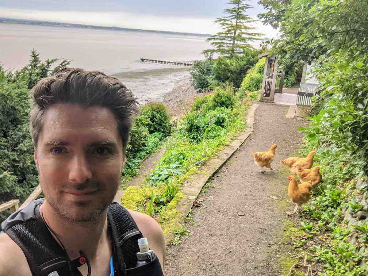
But your first challenge is finding the start line pictured below, chickens included…

Bowness-on-Solway is a tiny village. If you see The Kings Arms. The pub is the unofficial start (or end) of the walk, depending on which direction you’re doing it.
It’s also a B&B if you fancy rolling out of bed an into the start line!
Head down the hill to a discrete hut, known as The Banks (pictured above). In the early 20th Century, The Banks was a Promenade, a place where visitors to Bowness could shelter from the sun and bask in the beauty of the Solway.
Walk through the pavilion under the sign which states that Wallsend is 84 miles away and that “Good luck go with you“. Before you know it you’re at sea level at Bowness Marsh with the shore to the left and head along the road (below) to Port Carlisle.

Don’t expect to see any remnants of Hadrian’s Wall at all in this section or for a long, long time! You’ll be reliant on your GPS watch or map to guide you, or the little acorns that decorate the official Hadrian’s Wall trail. I must admit I got a bit disorientated at points on this stretch, so it pays to know which direction you’re headed and to trust your instincts, particularly if you’re up against the clock. Allow for the odd fun diversion too, whether that’s patches of the route under repair or sheep obstacles J

You’ll pass through a number of quaint villages, including Drumburgh, home to Drumburgh Castle, a small pele tower built to provide defence against Scottish invasion. The trail exits the village at the River Eden which is easy enough to follow 8 miles into Carlisle. This scenic route was one of my favourite parts of the entire trail. Bar the odd dog walker, you’ll embrace the solitude in full confidence the wide and winding Eden is guiding you the correct way.

Carlisle beckons and you enter the city at leafy Bitts Park about a mile from the centre. I clocked Carlisle Castle about five minutes before this point, excited at the prospect of being refuelled with a big pub lunch.
Day 1, Afternoon: Carlisle to Greenhead (18 miles)
I picked the route back up at Bitts Park, following the river for a short stint into the charming Rickerby Park before hitting remote country lanes. I totally lucked out with the weather, if anything it was too hot and I was left a bit exposed under the sun’s blistering rays. Woodlands bringing welcome but occasional relief from an otherwise wide open Cumbria into Northumberland.
Still no masonry to be found at this point. Instead, you learn to look out for the humps and bumps in the ground, discrete wall ditches, or the reassuring National Trail acorn. You’ll experience very long stretches of remote countryside during this stage of the trial with very few opportunities to top up on snacks, bar the odd honesty box attached to a place of residence. My top tip here is to ensure you pack loose change – I didn’t and ran out of water about 40km in, with 15km or more still to go. Rookie mistake on my first day!

Although you don’t see much in the way of Hadrian’s Wall you do pass a few villages with “wall” in their name (e.g. Walby, Oldwall, Walton). A owe a huge amount of gratitude to the Walton Reading Room Café for fuelling the second half of this stretch as it’s one of the only places you pass that accepts card payments.
Stand out moments of the afternoon were the Avenue to Newtown with its enclosed boulevard feel, the picturesque Weir in Cam Beck and near Harrows Scar (below), and the hillier line of the wall nearer Newtown (also pictured below).


A special shout out goes to the Lake District views near Pike Hill Signal Tower too (below).

About 10km out from Greenhead you’ll embark on the finest and longest intact remains of the wall at Willowford Wall and Birdoswald Roman Fort. Nestled next to the River Irthing, the wall dips and winds through the countryside taking in the ruins of the Roman fort, a turret and milecastle, onto the Willowford Bridge, a tremendous feat of Roman engineering dating back to 122 AD.

About 55km into my Hadrian’s Wall at this point, I was over the moon to reach Greenwood and my first night’s digs at Blenkinsopp Castle Inn. We stayed in the new rooms at the back of the coaching stables. Unassuming and extremely comfortable, beaten only by the hospitality and food in the bar area. I can thoroughly recommend the teriyaki salmon!
💌 Inspiring Run Stories.. in Your Inbox
Day 2: Greenhead to Corbridge (24 miles)
The Hadrian’s Wall trail isn’t high altitude by any means, but almost all of the incline was condensed into this second day as the guide book attests.
Thankfully those peaks also grant you the most breathtaking views, making it the most rewarding. It’s no wonder this is the most popular stretches of the trail, with coaches full of tourists decanted at the car parks of Steel Rigg and Housesteads Crags, queuing up for the obligatory Robin Hood Tree selfie (RIP).
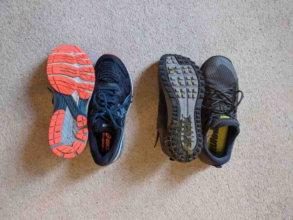
With large swathes of the wall intact and well-trodden paths there’s minimal risk of you getting lost en route to Corbridge. However, given the climbs and morning dew, I did opt for a change of footwear, swapping my Asics road runners for a pair of Nike trail shoes.
You start the day sizing up Walltown Crags (pictured below), making your way towards the disused quarry at Cawfield (also below) and Burnhead.


You’ll spend the next few hours tackling the undulating hillsides of the majestic Whin Sill. Formed 295 million years ago when stretching of the Earth’s crust caused 1000°C magma to rise up from deep within the Earth and dictate the undulating slopes of three counties – Cumbria, Northumberland and County Durham.
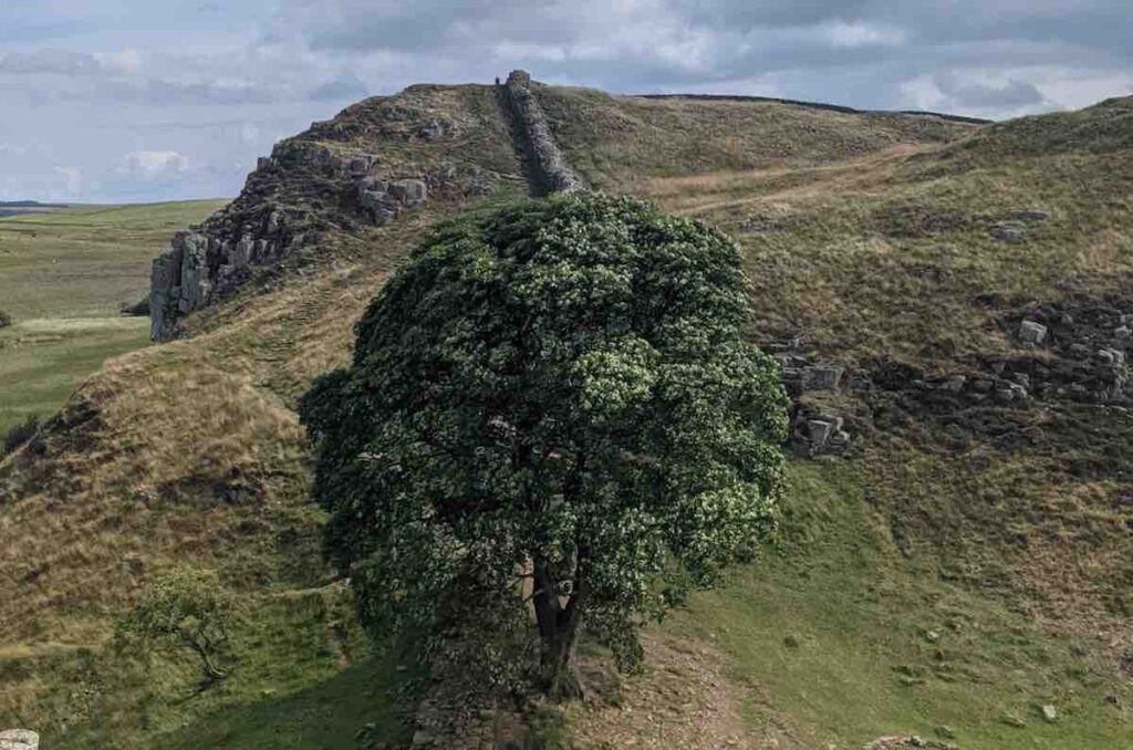
If you have a picture in your head of Hadrian’s Wall it’s likely of Winshield Crags and Caw Gap, the highest point of the wall. Every twist and turn represents another photo opportunity. The most famous of which being the most photographed tree in the UK. A lone tree proudly stands in Sycamore Gap, a natural gap in Steel Rigg, universally known as the ‘Robin Hood Tree’ since its standout performance in the 1991 film Robin Hood, Prince of Thieves.
The Sycamore Gap tree was one of the only landmarks I knew to look out for. A majestic sight and sanctuary. Not only from the elements but for the soul.
What a great loss it now is.
The magical Housesteads is only a short distance away. One of only 16 permanent bases along Hadrian’s Wall, it’s the most complete example of a Roman fort in Britain.
That inspiration carries you throughout the rest of the day as you travel through the rugged terrain of Northumberland National Park.
The wall continues through Sewingshields Crags before breaking into beautiful woodland at Sewing Shields. You then follow the route of the Military Road (B6318), a rather uninspiring part of the journey but one that’s easy to follow. Middayish and having exhausted 70% my water supplies in the heat, I was starting to flag in at this point so relied on Google Maps to find me a nearby refreshment stop (top tip: check this out this article if you want more advice for running in hot weather). It led me to Chesters Teamroom, a quaint wooden hut at Chesters Roman Fort near Chollerford, run by English Heritage. I filled my boots – real lemonade, a slice of carrot cake, sandwich and coffee – taking a short but well-earned rest on the picnic benches just outside.

Then it was a short stint towards my overnight accommodation in Corbridge. This last part of the trail is rather barren land, lacking in any real visual stimulation as you pick up the B6318 again.

You’ll switch between grass, wall, vallum and the frequent dips and blind summits of the Military Road itself until reaching The Errington Arms pub at Portgate.

This spot has a colourful history, tracing back to the 1750s when it was originally a coaching house. The roundabout on which it sits was once an impressive military gateway. I allowed myself a brief moment of celebration at reaching Mile Castle 22, which meant I had less than a marathon to go on my final day. Onwards to The Wheatsheaf, Corbridge…
A small chain pub in a small but beautifully formed village it had everything we could ask for. Decent portion sized pub grub. Cold lager. Tiny but otherwise comfortable beds. And a buffet breakfast. I regretted not getting a room with a bath but sleeping in my compression socks rejuvenated my calves did the trick.
Onto the final day…
Day 3: Corbridge to Wallsend (21 miles)
Back in my road shoes, I picked the trail back up at The Errington Arms pub at Portgate.
With under a marathon in distance to go the smile on my face meant I practically floated to Wallsend. The football fan in me had heard of Wallsend before for its famous Wallsend Boys Club which had a role to play in the development of the likes of Michael Carrick, Alan Shearer, Fraser Forster.
The first 10 miles is the last of open countryside and visible wall and Roman history. It’s all too easy to get your head down and let this moment pass, but do try to take in the wonder of these miles, and the last of the vallums and tree-lined avenues.

You’ll have most of what’s left of Northumberland to yourself, marauding over farmland, down discrete tracks and crossing ancient battlegrounds.
The first photo opportunity – at which I failed to take any photos – is Whittle Dene reservoirs. There’s a bit of activity here as it’s a popular site for twitchers, keen to spot swallows, swifts, curlew and even the occasional osprey. It’s otherwise very tranquil and I always find there’s something very soothing running near water.
The next major marker is Heddon-on-the-Wall, where you turn off Military Road for good.

This is the last long stretch of Hadrian’s Wall west of Newcastle albeit relatively small to anything encountered the day previous. You exit the built-up area at a steep (and very welcome!) 2km or so descent down remote lanes and roads through a golf course into a rather stunning Tyne Riverside Country Park.
Follow the vast Tyne along its river bank and join other walkers, mountain bikers and families enjoying a picnic in its 200 acres of meadows, woodland, open planned grass areas and walkways. After being heckled by a small gaggle of local kids who were asking how far I’d run and why I wasn’t going faster I grabbed a much-needed ice cream from a van in the park. The best £1 I’ve ever spent!
In a bit of a plot twist my friend Glyn decided to join me on the final 10 miles of the Hadrian’s Wall trail. I was incredibly grateful for the company at this point and it was fitting that we’d complete it together. We met at Denton Dene, a small oasis in the Scotswood part of the city which is also home to Newcastle Blue Star Football Club.
Enjoy the tranquillity is briefing punctured as you cross a footbridge spanning the noisy A1 but you rejoin your companion for the final 10 miles before long, the River Tyne.
You’ll pass by all seven bridges, including Redheugh Bridge and King Edward VII Railway Bridge, Queen Elizabeth II Metro Bridge (pictured below) onto Newcastle’s iconic Grade II* listed Tyne Bridge.

I lost a weekend one night in Newcastle a few years previous so it was great to be back seeing a different side of it. Whilst entirely tarmac, I really enjoyed this stretch of the route taking in the Quaysides and Baltic Arts Centre. Depending on what time you pass through you’ll also experience a glimpse of Newcastle warming up for a night out in the riverside bars – quite something!
Now you have a choice to make as you head towards Wallsend – follow the true path of Hadrian’s Wall through the city centre or the Long Distance Path along the River Tyne. I chose the latter, or my GPS route did. I didn’t regret it one bit as it’s the most direct route and has a lot more to it than getting lost in housing estates.
The trek from Newcastle to Wallsend is a trip back in time. You’ll soak up Newcastle’s industrial past and head through the St. Peter’s neighbourhood, one of the oldest in Newcastle. Over the centuries it has been home to world-leading shipbuilding, pottery and engineering sectors and it shows with a peaceful marina, quiet streets and woodland paths.
It’s only a short distance to Wallsend and you can feel it in your bones. The final piece of the wall is very understated and could be easily missed if you’re not careful. I stopped for a photo and a souvenir t-shirt in the tourist shop that’s attached to The Fort museum and café.

Wrapping Up An Epic Adventure Running Hadrian’s Wall

On my final few steps of running all 134km of Hadrian’s Wall I was greeted with mix of emotions. Extremely grateful for the experience and a chance to see this incredible part of the UK, but on a bit of a come down. What would I do with myself next?
First, a short trip on the Metro back to Newcastle for a celebratory beer!
But little did I know it would rekindle my love of running and spark the many running adventures I now write about on rundure.com.
Good luck for your own Hadrian’s Wall adventure. Remember, do your research and read up on other people’s Hadrian’s Wall route experiences, such as Karina Megget’s reflections from walking the Wall.
→ Further reading: What to Pack for Hadrian’s Wall
Advice for Walking or Running Hadrian’s Wall
If you want to tick walking or running Hadrian’s Wall off your bucket list you need to plan it properly.
Thankfully, I’ve done all the hard work for you. The is a round-up of my research and experience of completing the Hadrian’s Wall trail in 3 days.
How long is Hadrian’s Wall?
Hadrian’s Wall Path spans 84 miles (135km) coast-to-coast across the north of England. Slightly longer than the 80 Roman miles long wall.
How difficult is the Hadrian’s Wall route?
The Hadrian’s Wall route is fast, flat and incredibly scenic.
The total distance of the Hadrian’s Wall route is 84 miles and it is well sign-posted in sections. Elevation is relatively gradual, the highest point on the path being only 345 m (1130 ft) high.
Therefore, walking or running Hadrian’s Wall across multiple days is very accessible and achievable.
What are Hadrian’s Wall milecastles?
The Hadrian’s Wall route has its own distinct markers. Remembering these will help you when retracing the wall. At every Roman mile was a small fort which acted as a fortified gateway through the Wall, known as a ‘milecastle’. Between every two milecastles were two small watch towers (‘turrets’) approximately 30ft in height.
The Roman army was stationed along the wall in 15 major garrison forts. The last defining feature you’ll encounter is the ‘Vallum’ or ditch, 6m wide and 3m deep, that runs alongside much of the wall beyond Newcastle.
→ History lesson: A Hike Through Hadrian Wall Path’s History
What is the best Hadrian’s Wall route? (West to East)
It is best to travel West to East along the Hadrian’s Wall trail – from Bowness on Solway to Wallsend. Doing so avoids walking head-on into the wind, sun or rain.
The 84 mile Hadrian’s Wall path crosses through a mix of majestic landscapes and terrains, particularly in the popular middle section through Northumberland National Park.
You’ll start at the coastline, pass through farmland, parkland and woodland, see Roman ruins and fully intact sections of the Wall and encounter never-ending Roman roads.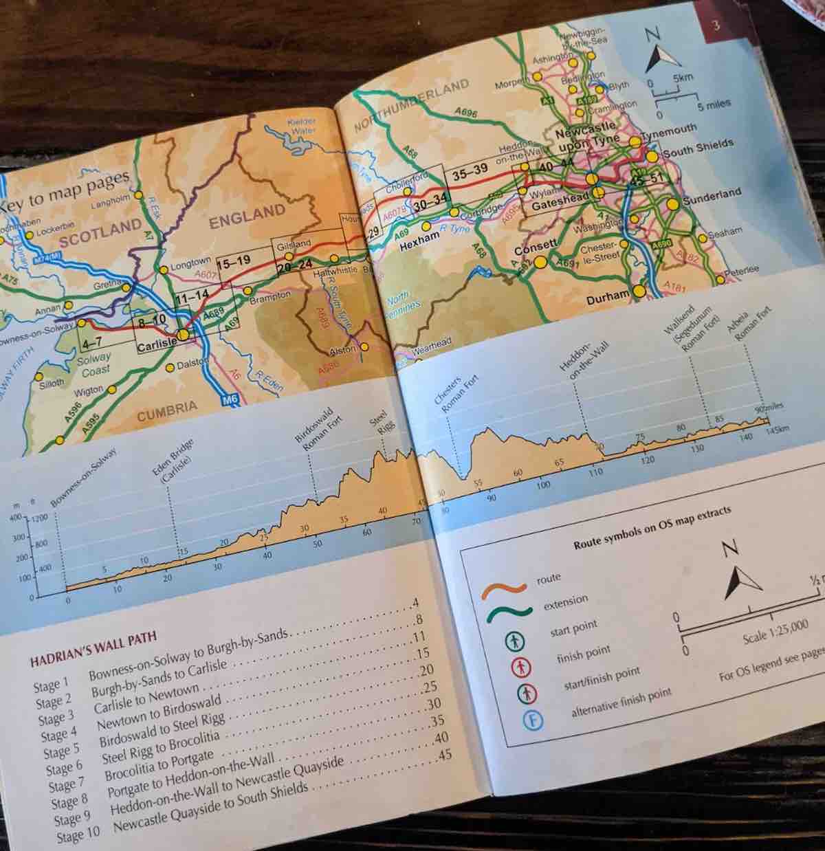
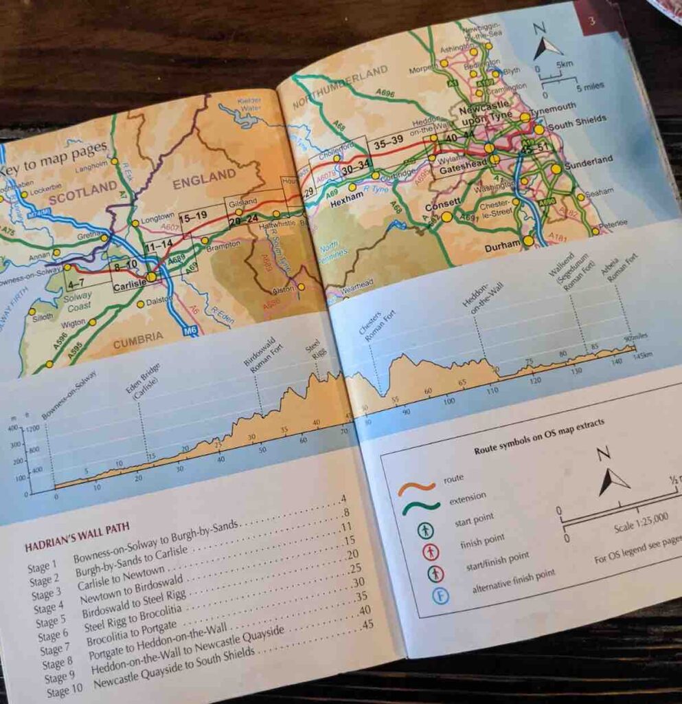
What is the best Hadrian’s Wall map book?
I bought this 1:25,000 OS Hadrian’s Wall Route Book, which proved very handy for plotting the route ahead of each day and working out key milestones along the way.
The Hadrian’s Wall route is well-signposted on the whole but having a pocket-sized map is advisable. This Ordinance Survey Hadrian’s Wall map book shows the full modern day line of the 84 mile (135km) Hadrian’s Wall Path, from Bowness on Solway in Cumbria to Wallsend (or the reverse) in great detail. It’s lightweight, durable and easy to follow.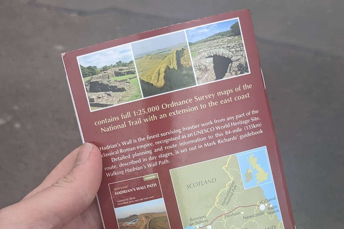
What is the best Hadrian’s Wall 3 day itinerary?
Day 1 morning: Bowness on Solway – Carlisle (15 miles)
Day 1 afternoon: Carlisle – Greenhead (18 miles)
Day 2: Greenhead – Corbridge (24 miles)
Day 3: Corbridge – Wallsend (21 miles)
What is the best Hadrian’s Wall 6 day itinerary?
Day 1: Bowness on Solway – Carlisle (15 miles)
Day 2: Carlisle – Walton (12 miles)
Day 3: Walton – Steel Rigg (14.5 miles)
Day 4: Steel Rigg – Chollerford (12.5 miles)
Day 5: Chollerford – Heddon-on-the-Wall (15 miles)
Day 6: Heddon-on-the-Wall – Wallsend (13 miles)
How many people visit Hadrian’s Wall per year?
Hadrian’s Wall is a popular tourist destination attracting 100,000 visitors per year. However, only 7,000 people run or hike the full length of the wall annually.
What is the best Hadrian’s Wall site?
The most popular section cuts through Northumberland National Park.
This includes the undulating hillsides of the majestic Whin Sill, the most intact stretch of walls and highest points at Winshield Crags and Caw Gap, and Sycamore Gap, featuring the ‘Robin Hood Tree’, so called since its standout performance in the 1991 film Robin Hood, Prince of Thieves.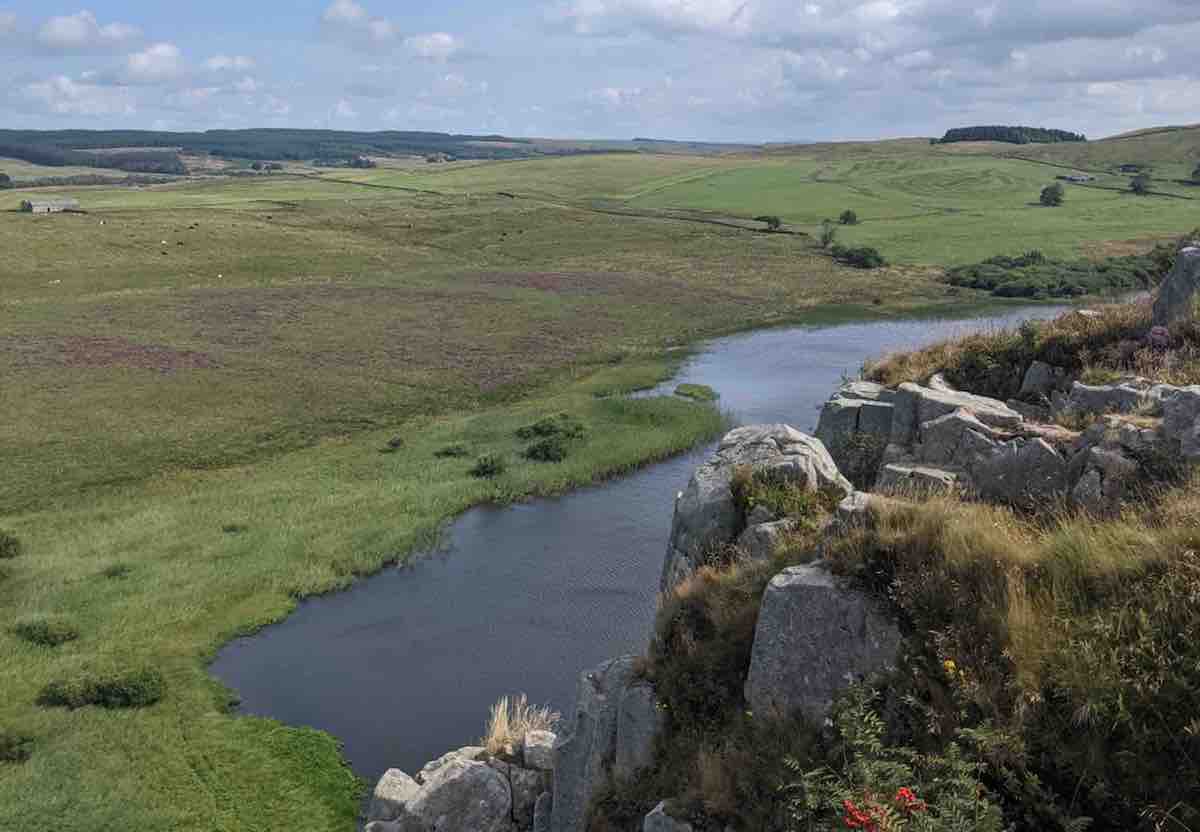
What are the best hotels near Hadrian’s Wall?
Hotels near the Hadrian’s Wall route I can personally vouch for are:
– Crown Hotel, Wetheral, Steele’s Bank, Wetheral, Carlisle CA4 8ES (near Carlisle)
– Blenkinsopp Castle Inn, Brampton, CA8 7JS (near Greenhead, milecastle 48)
– The Wheatsheaf, Corbridge, NE45 5HE (near Corbridge, milecastle 21)
– Hotel du Vin, City Road, Byker, Newcastle upon Tyne NE1 2BE (near Wallsend)
What is the best time of year to walk Hadrian’s Wall?
The best time to walk Hadrian’s Wall path is between May and October, when average temperatures are 10.5 °C to 15 °C. See the chart below for average temperatures and rainfall of the Hadrian’s Wall route.
With 100,000 visitors per year, the Hadrian’s Wall route is well worn and muddy when wet in patches. Therefore, it many walkers choose to give the trail time to recover over winter.
I have run Hadrian’s Wall in August, when it gets popular with tourists and extremely hot, with minimal sun cover.
If you’ve any other questions, please feel free to ask away in the comments and I’ll do my best to answer them.
Hi there
Thank you for inspiring me to do this challenge
Would it be possible for me to do this self supported in 3 days do you think ?
Can you get enough food and water along the way ?
I’m an Ironman triathlete so have endurance experience mentally and physically !
Thank you for your help
Hi Clare, firstly good luck! Let me know how you get on.
Food and drink wise: there’s certainly long stretches (up to 15km) where there’s slim pickings, however others were you’re spoiled for choice. My advice would be to stock up where you can, carry coins for the makeshift tuck shops, and take more water than you’ll think you need.
Accommodation wise: It’ll narrow your hotel options but it’ll just take more planning. There’s a number of services that will collect and drop off your bags for you at the start and end of each day.
Fitness wise: I doubt you’ll have an issue given your background and the training you’ll undoubtedly put in. Your GPS watch will be your best friend as it’s difficult to navigate the route at speed using a paper map and the signposting is non-existent in patches.
Hi there. I’ve been toying with the idea of running Hadrian’s Wall next year and I found this page really helpful in both considering the practicalities and inspiring me to not dismiss the endeavour as unrealistic.
I was curious: your page says you downloaded a .gpx file with the Hadrian’s Wall route on it, but there’s no link to the .gpx route. Do you still have the link or know where I could source it? I’m curious to examine it in more detail.
Thanks in advance.
Simon
Hi Simon. Sorry about this. I’ve readded the link to download it – let me know if it works or not. Good luck with running Hadrian’s Wall, let me know if I can help in any way!
Hello, great article.
Where is the link to the Hadrian’s Wall GPS route please?
Hi Stephen. I’ve added a link to download a Hadrian’s Wall GPX file via Dropbox. One thing to note is route is East to West, so you wish to reverse it in the watch, as I did. Let me know how you get on!